Wednesday
I don't think we have ever given Denver a fair chance. every time we have been here we have driven straight through on I70, or round the suburbs, like Aurora. So today we decided we would 'do the town'.
The sun was shining and it was warm. The campground is only about twenty minutes from the Centre of Denver. We headed straight for the Capitol, found a nice parking spot in the Capitol grounds, went for a quick Cof/T in the Capitol Cafe, where we were surrounded by people talking earnestly. We were just in time to make the 11.00 tour, which was led by a dear lady who had been a 1st grade teacher. The Capitol building was quite grand, having been built in the 1890's, lots of rose quartz on the walls, very nice. The overriding feature of this Capitol was that it is the first one of the eleven we have toured that is actually in session! (some may have been in session, but we have toured the ex-Capitol building, e.g.North Carolina). It wa amazing how it transformed the building from a cathedral like place to a vibrant, buzzing arena. We were shown the house of Representatives and the Senate, even though very little was happening there were people all over the place, nobody seemed to be listening to whoever was speaking. All the men seemed middle aged and overweight, all the women seemed younger and trim.
After enjoying the Capitol bilding we stopped in Tom's Diner for a pleasant, but standard, lunch before sauntering to another of the Denver landmarks; the house of Margaret Brown. Better know to many as Molly Brown, even better known after her survival of the sinking of the Titanic as The Unsinkable Molly Brown. She was no lightweight. Born in by the Mississippi in 1862, walked the immigrant trail to Colorado, ended up in Leadville, married a mining engineer, helped organise the mining unions. Husband struck it rich, they became part of Denver society, she still worked for union rights and women's emancipation in the 1910's and 20's. Survived the sinking of the Titanic (already said).Became an actress at the age of 60 odd. Died in 1932. They reckon a more powerful story than fiction. It's great to find a woman who can become a hero and role model.
We did not tour the house, as it is not accessible, but did watch the video, which was interesting.
Our third stop was the 16st Mall, a shopping street closed to traffic and paved over. Lots of shops, people and happening things. We had a nice stroll down the street, Sally found a nice top in Ross Dress for Less and we had a Coff/T in Starbucks before leaping on a bus (free busses) to be taken back down the Mall, to walk back to our car and drive through Denver Drivetime to our trailer in Golden. We both agree that this was was a very pleasant day.
Wednesday, April 29, 2015
Tuesday, April 28, 2015
Golden CO
Tuesday
Well the windshield guy did turn up and has replaced the windshield, haven't tested it yet though.
That about brought us to lunch time. The weather by now had become sunny and warm, so after lunch we took a stroll into town along the lovely riverside walkway. Had a good look round the historic main street and a Coff/T in a small bakery, very nice.
As well as the historic main street and the Clear Creek, Golden, it seems has a lot to offer. There is a beer factory - Coor's, which offers tours. A mountaineering museum, a mining museum, a railroad museum, an outdoor history museum and a town history museum as well as the beautifully appointed parks and the whitewater canoeing course, all linked by nice smooth concrete pathways. Even though it was only Tuesday there were lots of people out walking, running, fishing, canoeing and hang gliding. It was still lovely and warm, so made for a very pleasant afternoon.
When we got back we found that our new neighbours are New Zealanders here for a mountain biking vacation, doing the loop round I70, Moab, Durango and back to Denver, really nice people.
More American Roads
Tuesday
Well I am getting so busy I can't keep up with the Blog!!!!
Sally is now getting into overdrive with her new camera and it can now take hours to sort photo's. So now at least we are getting pictures of me as well as Sally. Keep it up Sally.
So, to pick up a weeks worth of travel!
Here is a thought about the roads we were traveling,as they are famous in USA. Everyone has heard of Route 66, and sometime ago I wrote a bit about U.S. Route 2, but here are some more that we have been traveling on recently
U.S. Route 550
From Chaco all the way up through Farmington, Durango and Ridgway to Montrose we had been traveling on Route 550, a North/South Road, which would take you from Albuquerque to Montrose, its most famous stretch being the 'Million Dollar Highway' between Silverton and Ouray. A route that has the Red Mountain Pass,which is notorious as a difficult mountain pass road, read the description of it in WikiPedia (yes they even describe roads), many RV people will not even attempt the road. WE ARE TOUGH though. Route 550 ends at Montrose, when it meets Route 50.
U.S. Route 50
Route 50 (see Wikipedia) is an East West road which is traceable from San Francisco right to Ocean City on the Atlantic Coast in Maryland. We have actually travelled on it when we drove up to Lake Tahoe, then again where it merges with I70, but separates briefly to go through Green River, which we travelled on to get a cof/T in Green River in October 2014.
We were due to be in Silverthorne, near Breckenridge, for the weekend of the 25th to see our niece Sarah and our great niece, Brianna, so we planned to take three stops. Ridgway to Silverthorne being about 230 miles. However on Monday we decided to take a side trip to Black Canyon NP, and stay overnight, that would still leave us more than 200 miles. It is worth remembering here that we were still fighting the seasons. Since coming up into the Rockies the weather had turned cold, it was below freezing every night. The trick was to find a campground that was actually open and had hook ups, but wasn't a real dive with lots of permanent residents. Ridgway SP had some, so we had stayed there, Black Canyon NPS website said that it did not, except one site on B loop that was ADA, yet on arriving we found that not it was not only the ADA site that had electricity , but that all of B loop was open and empty. Fortunate really, as the ADA site was very small, ADA may well have stood for American Dwarf Adapted.
Getting to Golden, CO
Monday 27th April.
The day dawned bright and clear, the snow was rapidly melting, which did not stop me from having to clear a three inch layer of snow from the roof of the slide out.
The tricky part of today was contacting our vehicle insurance. We had taken the vehicles out of storage when we returned to Phoenix and renewed the insurance starting yesterday. I had been sort of thinking that the premium this time was quite low. Today I checked it!!!!! No collision coverage!!!!!! NO collision coverage since we had taken it out of storage!!!!!!!!! If we had had an accident we would have had no insurance coverage at all!!!!!! I kind of got spiky about this. The dear lady on the phone - Jasmine, then informed me that she could not change the coverage for 24 hours (I might have just had an accident and then make a fraudulent claim). However, gentle persuasion won the day and eventually she got the supervisor to give us instant coverage. Just as well, as we had to be off the site by 11 that morning and we had a site booked down in Golden, near Denver. We breathed a great sigh, but it was quite stressful. I have asked them to review the conversation I had on 25th March, as I know that I requested the collision coverage be returned to the Chevy. The stupid thing is that when they do capitulate I will have to pay the difference between the two coverages!! In case some previously undeclared claim is made against me. You just can't win against the big boys.
We eventually got packed up - we were not too worried, we were only travelling 65 miles and the later we left the more time the roads had to dry out and time for snow to melt off the roof of the the trailer. I estimate that the three inch depth of snow on our 240 sq ft roof would add about 900lb weight to the trailer! So the more that melted the better it would be. Just to help that we stopped at Safeways in Dillon for a cof/T (and a secret donut) before I pick
ed up some shopping and we drove off.
The High point on I70 is the Eisenhower Tunnel, built through a mountain it takes us across the Continental Divide. I reckon that we have crossed the CD in eleven different places on our trips (three places in the last three days) The Eisenhower Tunnel was the first place we crossed it in 2003. We are now planning to travel on the East side, so it looks like this may well be the last time we ever cross it. Oh Dear, that has hit hard.
We left the I70 to travel on U.S. Route 6, to a northern suburb of Denver called Golden. U.S. Route 6 is another one of 'those roads'. It is in fact the longest continuous road in the U.S.A., over 3000 miles long, it stretches from Bishop in CA to Provincetown, MA., though originally it started at Long Beach CA. It is called the Grand Army Of The Republic Highway (Wikipedia), we traveled on it in Long Beach, going through Tonopah (NV) and from Provo to Green River UT. The road winds through about twenty miles of narrow rocky gorges, following the Clear Creek River. It is a beautiful drive, though a bit slow with a trailer on the back.
Route 6 brought us right to the campground. We were assigned a site between the ex wife of a really nice guy called Rude DOG, (I think that is the spelling) who is/was a biker, now turned Christian (DOG stands for Depend On God), who has promised to turn up tomorrow with his Harley, as Sally foolishly said she has never ridden a motor cycle - watch this space!!!!!!
And a lovely couple Susan and Kerry Garcia. Susan told me almost immediately that Kerry was a world champion bull fighter in the 1980's, and instantly invited me into their trailer to show me his silver belt buckle and competition plaques. In passing, as you do, she mentioned that when he was a hunter he nearly lost his life in a snow drift - he and a buddy were stuck for 7 days, couldn't get out of the car as the snow had jammed the doors shut! Lived on beans and biscuits. They are a lovely couple.
Went for a run this evening and discovered that Golden has some lovely concrete paths, which go along the river to the old part of town, so we may explore that tomorrow, so more about Golden tomorrow. Once the Jiffy Lube man has been to replace the windshield.
Oh didn't I mention we had booked that in? Did I not mention that we got a stone chip as we drove through Chaco Canyon? Well, we have watched the crack grow steadily over the last two weeks and now it is time to replace it. The guy comes at 8.00 tomorrow.
Monday, April 27, 2015
Weekend to Relax
Friday
We had arrived at Tiger Run on Thursday, exactly on schedule, thanks to a great run the day before which took us right through the middle of the Rockies.
Unfortunately the weather has deteriorated and it looks miserable and it is cold.
On Friday we took a relaxed visit to Clint's for coff/T and a goodie (Sally had a somehow vegan, gluten free, chocolate cup cake) where we Facetimed with Helen, to reminisce about her time in Breck many years ago, when she worked here.
In the evening we had our niece Sarah, her daughter Brianna and Sarah's boyfriend Doug over for a meal. On both Saturday and Sunday we hung out in Sarah's very nice house, playing board games and watching videos with Sarah and Brianna, which was lovely, no pressure and great fun. We went out to the Red Mountain Grill on Saturday night for a very pleasant meal with good company. Sunday evening we had to say farewell to Sarah and Brianna, not knowing when and if we would ever actually see them again!!!
Friday, April 24, 2015
Monarch and Fremont Passes
The roads we had chosen would take us over some of the highest roads in North America and seeing as we were chasing the winter up through the Rockies there was a good chance that we would come a cropper with the weather sometime. We had triumphed over Red Mountain Pass (11,018ft), on Sunday, back at Ouray.
Thursday
Next morning we set out to drive through Gunnison. After leaving Gunnison behind we had to climb up to Monarch Pass, over the Continental Divide (CD) (11,312ft) hoping that it would be not be icy (not nice with narrow roads, twisty without protective barriers). Amazingly we found that it was sunny and warm at the top, with very little wind. The roads were clear and dry. Good, considering that a week before the road had been closed because of snow. Descending the other side to Salida where we were to have lunch. The great news was that we actually managed to get away by 8.37 in the morning, a record. This meant that rather than having Cof/T at Gunnison and lunch at Salida, we were in Salida by 11.00, so we stopped there for cof/t in a family restaurant.
Salida is relatively low, but as we moved North to Leadville we started climbing again the country became progressively more rugged and 'Glenlike', the weather started to close in as we hit the cloud base and we had to outrun the snow flurries to Leadville.
We stopped in Leadville for lunch which we ate at Doc's Grill, Wings and nice soup for me, chicken salad and soup for Sally. Leadville is a quaint Victorian mining town, now full of gift shops and restaurants.
Over lunch we made the decision to press on to Tiger Run Campground at Breckenridge. This would take us onto Route 91 - 'The Top Of The Rockies' Scenic Byway, going over the Fremont Pass (CD again), 11,318ft one of the highest passes in the USA. Fortunately the poor weather at Leadville now gave way to being sunny and calm! From here it was a short run on I70 then through Frisco to our campground at Tiger Run.
Coyote at Elk Creek
Wednesday
We got back on track on Wednesday and camped at the Elk Creek NRA Campground, on the Blue Mesa Res. A mere 50 miles down the road from Black Canyon. Simply because (a) it was open, (b) it had electric hookups and we needed the heat, it was freezing!
Had a nice talk with the ranger, who waved his hand to encompass the campground (open brush and sand) and the reservoir, which we were beside, saying what a lovely campground this was. In the next breath he noted how quiet it was now that the wind had stopped. Then he revealed that it normally blows a gale up the valley and through the campsite. Then he said how warm it was (I was freezing), as normally this was one of the coldest places in Colorado, often recording temperatures of -20F (I think that is about -25C). I then realised that 'lovely campground' is a relative term.
I did get a run in though, about 4 miles up Haystack Gulch. A narrow valley that climbs away into the hills to the North of the campground, with crags on either side. I was pleasantly surprised to see three mule deer sort of running ahead of me, half way up the valley side. All of a sudden a herd of about a dozen crossed my path and scampered away. I realised that if I had disturbed them they would be running away from me, not across my path, so looked up to where they had come from and there up under the crags was a large animal, about the size of a small deer, which is what I thought it was, but no it was dog like, I thought it was a wolf. It quickly ran up to the top of the crag, stopped and looked down at me then disappeared over the horizon. Now very few wolves have been seen in that area, so I must accept that it was probably a coyote, but it looked very wolf like to me. Anyway I had gone two miles and thought it was about time to turn and head back to the trailer.
We got back on track on Wednesday and camped at the Elk Creek NRA Campground, on the Blue Mesa Res. A mere 50 miles down the road from Black Canyon. Simply because (a) it was open, (b) it had electric hookups and we needed the heat, it was freezing!
 |
| Friendly looking place |
 |
| Looks mean, but passed to the North |
Had a nice talk with the ranger, who waved his hand to encompass the campground (open brush and sand) and the reservoir, which we were beside, saying what a lovely campground this was. In the next breath he noted how quiet it was now that the wind had stopped. Then he revealed that it normally blows a gale up the valley and through the campsite. Then he said how warm it was (I was freezing), as normally this was one of the coldest places in Colorado, often recording temperatures of -20F (I think that is about -25C). I then realised that 'lovely campground' is a relative term.
I did get a run in though, about 4 miles up Haystack Gulch. A narrow valley that climbs away into the hills to the North of the campground, with crags on either side. I was pleasantly surprised to see three mule deer sort of running ahead of me, half way up the valley side. All of a sudden a herd of about a dozen crossed my path and scampered away. I realised that if I had disturbed them they would be running away from me, not across my path, so looked up to where they had come from and there up under the crags was a large animal, about the size of a small deer, which is what I thought it was, but no it was dog like, I thought it was a wolf. It quickly ran up to the top of the crag, stopped and looked down at me then disappeared over the horizon. Now very few wolves have been seen in that area, so I must accept that it was probably a coyote, but it looked very wolf like to me. Anyway I had gone two miles and thought it was about time to turn and head back to the trailer.
Thursday, April 23, 2015
Black Canyon National Park
Tuesday 21st April
A lovely sunny day greeted us as we set off early for our next stop. Originally we were traveling to Gunnison, but had heard from our ranger about Black Canyon National Park, which was a mere 5 mile off our route, so we endeavoured to go and have a look, So tempted were we that we decided to stay the night in the campground, no water, but electric hook-up for $9.00 per night. Black Canyon NPS website had said that it did not, except for one site on B loop that was ADA, yet on arriving we found that not it was not only the ADA site that had electricity, all of B loop was open, hooked up and empty. Fortunate really as the ADA site was very small, ADA may as well have stood for American Dwarf Adapted.
Once we had set up camp we set off to explore The Black Canyon
Once we had set up camp we set off to explore The Black Canyon
First stop was the Visitor Centre, where we watched a very interesting video, then sat in the sunshine and ate our lunch, before tackling the Black Canyon.
Unfortunately words fail us yet again and we are stuck with the old superlatives of awesome and stupendous and magnificent, because this truly was all of those things. It was a canyon gouged out of the mountain range by the Gunnison River, straight down from rim to river over 2000ft. the canyon sides were huge slabs of metamorphic rock, shiny dark grey, with huge white veins of pegmatite, creating an effect like a giant marble cake. Its magnificence comes from being so narrow and so deep and with such vertical sides. And so big, it is over 50 miles long. So difficult is the terrain at the bottom that it was not explored properly until 1880, some thirty years after the Grand Canyon had be tamed by Powell.
There is a road which travels along the south rim of the canyon, giving us more than half a dozen new and jaw dropping views of the Black Canyon. The trouble is that such scale is difficult to capture with a photograph, also the splendour is actually quite tiring, so after we had our fill of gawping we drove gently back to the trailer, where we had another campfire, courtesy of the surrounding campers, who had left their wood behind after their weekend camping.
Wednesday, April 22, 2015
Ridgway State Park
Sunday
We had decided that it would be nice to stay for two nights here. Our camp site on Ridgway SP was very pleasant, overlooking the Uncomprahgre River, and it would be nice to relax for a bit. I took the opportunity to have a run round the SP on Sunday afternoon and having been directed to the pile of driftwood we had a smashing campfire.
Monday
Got up early and managed to get some nice pics of the park before we moved on to Black Canyon NP
We had decided that it would be nice to stay for two nights here. Our camp site on Ridgway SP was very pleasant, overlooking the Uncomprahgre River, and it would be nice to relax for a bit. I took the opportunity to have a run round the SP on Sunday afternoon and having been directed to the pile of driftwood we had a smashing campfire.
Monday
Unfortunately yesterday’s sunny weather was not to be repeated. In the middle of the night it rained a the morning was cold and grey, so at least we had a relaxed morning, as there was no incentive to go out. Today was also our friend Linda’s funeral, so we spent a fair amount of time thinking about that and being in contact with the kids, who had attended the funeral. Right as we were talking with Helen’ family we got a cloudburst, which turned to hail, making conversation difficult, but not impossible. After lunch the weather cleared, so we took a drive out, first to the other visitor center in the SP, then on into Ridgway. I have written a special blog about our 'trip' in ridgway. On the way there we passed a 'heron rookery', apparently the correct name for it. It was quite strange to see these big birds perched in the tops of trees, sat on very sticky nests.
TuesdayGot up early and managed to get some nice pics of the park before we moved on to Black Canyon NP
Up Up and Over
Sunday
After the miserable weather we have had over the last few days today was bright and clear, after only a few miles the mountains rose up on either side and we slowly climbed alongside the Animas River, then away up a side valley. We were not in a hurry, so we just let the Chevy climb along at between 30 and 50 m.p.h., not putting any strain on the engine. It was a very pleasant drive, the mountains were still covered with snow, but the road was dry and clear, very pretty, but to both of us the highway was not as spectacular as the railway had been back in 2003.
We arrived at Silverton and drove into town, it was more like a ghost town. We drove down Main St, one of the few paved roads in town. It was wide and quiet. It was time for cof/t, where to stop? the famous Black Bear Cafe? Closed! As was every cafe and hotel in the town. It was only April - the train was not scheduled to run for another two or three weeks. The town was closed! At the end of Main St we turned the rig and spied a small cafe - Kendall Mountain Cafe. It was OPEN!, we pulled in and sat for a bit with a drink and a cup of potato and bacon soup between us, very welcome in the cold sunny air, it was actually homemade, very nice. After the usual bit of chat with the waitress/owner and most of the half dozen customers who were there/came in while we were there we moved on.
Taking to the side streets we tried to find the Christmas Shop where we had been short changed back in 2003. everything still closed, including the Chatanooga Cafe, where we had eaten last time we were here. We did see some signs of life as shopowners were starting to freshen up their premises for the impending summer traffic.
When we visited in 2003 we had toured the shops and found three very nice pottery angels in a little Christmas Shop, each about 10cm high. We bought them, the lady wrapped them in bubble wrap, packed them individually in three cardboard boxes and we carried them home very carefully in our suitcases. When we got home (UK) we unwrapped them to show to the family, only to find that there were three boxes, but only two angels, one had either not been packed, been removed en route home, or, being an angel, simply flown away. Anyway we were going to return and have this out with the owner! Only problem was it had gone! Couldn't find the shop, didn't exist any more! We found the photo shop, where you could dress up as a cowboy, or card sharp, or Madame, where we didn't get our photo taken. But no Christmas Angel Shop, perhaps it was one of those special shops that lives trans-dimensionally and only opens on the Earth Side at Christmas, or when special people come to it, at special times, like we did in 2003. We we did enjoy looking, but had to move on.
Leaving Silverton we had one more pass to climb - Red Mountain Pass. Now the road took on a more rugged nature, snow closed in on withe side, the road narrowed, in places was cut into the rock, with ice falls along the way where snow had melted, run down and frozen into icicles and ice walls. On the on the side it dropped away sheer, with no crash barriers, we moved more to the center of the road, as there was very little traffic. The views were now in the spectacular class! Climbing further we now met traffic parked at the side of the road, skiiers out for a Sunday Cross Country Ski. Lots of snow, also derelict mine workings from a long time ago (it was not called Silverton for nothing), made Christmas card images as we traveled. Then we hit the top and started the winding road down the other side. The weather was still and sunny, which meant the in the sun it was hot.
Now the views went from the spectacular to the stupendous, the road twisted and turned, but was manageable. The valley aheahe opened up with mountains on either side, a range of colours made it look beautiful, more beautiful than can be shown in photographs. We traveled downwards as slowly as we could, taking in the views, each twist in the road gave us another view. We reached a major stopping place and decided this would be good for lunch. We got out and took pictures up and down the gorge/valley. The we noticed that there was a viewing point which reached out over the cliff below us, the metal grating floor meant that Sally was unable to go very far, but down below us water gushed from under the road, from a small stream, and fella couple of hundred feet to disappear into a a tunnel of snow and ice, made by the spray. At this point words failed us. We just stood and looked at this amazing view.
We sat and ate our lunch, idly chatting to other people who stopped for the view, then continued downwards to the town of Ouray, which stretched along a shelf in the valley floor, another old mining town, like so many we had passed through, sleepy with signs of abandonment, just waiting for the summer tourists to come this way after Memorial Day in May.
The road now leveled out and straightened up, we were able to make good time to our campground - Ridgway State Park. After filling with water we found a very nice site overlooking the Uncam River, below the dam, set up and relaxed with burger and salad for tea.
Having enjoyed our wander round Durango we hitched up and headed North, continuing up Route 550. This road would lead us up into the Rockies proper, first to Silverton then over the Million Dollar Highway through Red Mountain Pass, this meant a climb from 6900ft to 11000 ft, before dropping down to Ouray and on to our destination for today - Ridgway State Park.
We arrived at Silverton and drove into town, it was more like a ghost town. We drove down Main St, one of the few paved roads in town. It was wide and quiet. It was time for cof/t, where to stop? the famous Black Bear Cafe? Closed! As was every cafe and hotel in the town. It was only April - the train was not scheduled to run for another two or three weeks. The town was closed! At the end of Main St we turned the rig and spied a small cafe - Kendall Mountain Cafe. It was OPEN!, we pulled in and sat for a bit with a drink and a cup of potato and bacon soup between us, very welcome in the cold sunny air, it was actually homemade, very nice. After the usual bit of chat with the waitress/owner and most of the half dozen customers who were there/came in while we were there we moved on.
Taking to the side streets we tried to find the Christmas Shop where we had been short changed back in 2003. everything still closed, including the Chatanooga Cafe, where we had eaten last time we were here. We did see some signs of life as shopowners were starting to freshen up their premises for the impending summer traffic.
When we visited in 2003 we had toured the shops and found three very nice pottery angels in a little Christmas Shop, each about 10cm high. We bought them, the lady wrapped them in bubble wrap, packed them individually in three cardboard boxes and we carried them home very carefully in our suitcases. When we got home (UK) we unwrapped them to show to the family, only to find that there were three boxes, but only two angels, one had either not been packed, been removed en route home, or, being an angel, simply flown away. Anyway we were going to return and have this out with the owner! Only problem was it had gone! Couldn't find the shop, didn't exist any more! We found the photo shop, where you could dress up as a cowboy, or card sharp, or Madame, where we didn't get our photo taken. But no Christmas Angel Shop, perhaps it was one of those special shops that lives trans-dimensionally and only opens on the Earth Side at Christmas, or when special people come to it, at special times, like we did in 2003. We we did enjoy looking, but had to move on.
Leaving Silverton we had one more pass to climb - Red Mountain Pass. Now the road took on a more rugged nature, snow closed in on withe side, the road narrowed, in places was cut into the rock, with ice falls along the way where snow had melted, run down and frozen into icicles and ice walls. On the on the side it dropped away sheer, with no crash barriers, we moved more to the center of the road, as there was very little traffic. The views were now in the spectacular class! Climbing further we now met traffic parked at the side of the road, skiiers out for a Sunday Cross Country Ski. Lots of snow, also derelict mine workings from a long time ago (it was not called Silverton for nothing), made Christmas card images as we traveled. Then we hit the top and started the winding road down the other side. The weather was still and sunny, which meant the in the sun it was hot.
Now the views went from the spectacular to the stupendous, the road twisted and turned, but was manageable. The valley aheahe opened up with mountains on either side, a range of colours made it look beautiful, more beautiful than can be shown in photographs. We traveled downwards as slowly as we could, taking in the views, each twist in the road gave us another view. We reached a major stopping place and decided this would be good for lunch. We got out and took pictures up and down the gorge/valley. The we noticed that there was a viewing point which reached out over the cliff below us, the metal grating floor meant that Sally was unable to go very far, but down below us water gushed from under the road, from a small stream, and fella couple of hundred feet to disappear into a a tunnel of snow and ice, made by the spray. At this point words failed us. We just stood and looked at this amazing view.
We sat and ate our lunch, idly chatting to other people who stopped for the view, then continued downwards to the town of Ouray, which stretched along a shelf in the valley floor, another old mining town, like so many we had passed through, sleepy with signs of abandonment, just waiting for the summer tourists to come this way after Memorial Day in May.
The road now leveled out and straightened up, we were able to make good time to our campground - Ridgway State Park. After filling with water we found a very nice site overlooking the Uncam River, below the dam, set up and relaxed with burger and salad for tea.
Tuesday, April 21, 2015
Not Alice's Restaurant - Special
Monday 22nd April
Ridgway SP is close to Ridgway, which is the epitomy of a ‘One Stop Light Town’. Built in a wide valley, with lots of cattle country around it. On the road into town is The True Grit Saloon, which is the Hotel used in the film of the same name, so Ridgway has a small claim to fame. The houses spread out, but there were a lot of places to eat and a small railroad museum, which we did not go into. We drove along Main Street, out of town, up a hill, took some panoramas then drove back down. Across the Stop Light was another small complex of about four buildings, disguising themselves as ancient wooden shacks. It advertised itself as The Trail Town Still. But the rangers at the SP had told us it was a rib place that smoked its own ribs, so we decided to try it out.
Trail Town Still, Smoke House and Shop
Surprisingly there are several reasons for going to a restaurant, only one of them because of the food. One reason can be because they are social centres, to meet people, or perhaps as a rendezvous point with someone you know. Or maybe you go there because they have something special, like the True Grit Saloon, because it was made famous (we once visited the Whistle Stop Café, simply because it was the Whistle Stop Café from the film).
Trail Town Still’s niched seemed to be its being close to the line. The line between legal and illegal. Firstly it was indeed a distillery, which brewed and distilled its own drinks, I think mostly ‘fruit cocktails’ from vodka or tequila type alcohol, I suppose because you don’t need to age it like whisky, but I know very little of that. These they served in the jars made famous by moonshiners. This place though was completely legal.
Second it was its own smoke house, where they smoked their own meat, sausage, chicken, beef and pork ribs, which they served with their own sauces, very tempting.
They served both the drinks and food in a ‘dive’ sort of saloon/converted shop, with bare walls, few tables, but plenty of places to stand, or lean against the bar. Interesting décor. For reasons we found out later, there was a steady stream of people. Its overriding positive feature was, as is often the case, the people, including the staff. Lots of local people, friendly, chatty people, it was a very pleasant atmosphere, almost like a front parlour where friends meet for a drink and chat.
Second it had a Smoke Shop, just a short step from Smoke House? No! No! and No!, however they do tread the same sort of line as the distillery. A Smoke Shop is, in almost any state in the Union a place to buy tobacco products. The growing exceptions being Washington State, Mendocino County and Colorado. In these places laws have recently been changed to legalise cannabis products! So now across those states a whole new industry has erupted, closely regulated, but able to sell cannabis products. This ‘Smoke Shop’ was there to sell cannabis, cannabis products and paraphernalia! Sally and I have never (poor sad people that we are) knowingly taken ‘social’ drugs and know very little about them, aside from what you read in the magazines or is served up in fiction books, none of which you would call ‘reliable’ sources. So here was our chance, we went into the shop and basically said “Hi, nice shop, although we are children of the sixties, we actually know nothing about social drug use, tell us more”. So they did. We learned quite a bit, some of which I will remember. They were very pleasant a helpful. They demonstrated several techniques and showed us several products. Their disappointment came when we said that we would only be in the State for about another two weeks. When we said we were traveling to Wyoming, their faces clouded. They made certain we knew that you did not want to get stopped in Wyoming with any hint of drugs. Still we spent a fascinating half hour or so doing ‘Social Drugs 101’.
From there we went to the BBQ shop/eatery, where we were also given a tour of the distillery. Strangely enough for a Monday, in the little space between the shacks there was a band setting up. Spoiler alert!!! By the way, at this point we are very close to one of those weird coincidences that appear very routinely on our travels.
Very nice, live entertainment, interesting sound, sort of acid rock, strange for a ‘One stop light town’, but what the heck. As we sat in the Trail Town Distillery, we noticed that the stream of people coming in, while not all the same, had sort of similar attributes. Some were old, some young, some close cropped hair, some long. Most seemed to wear loose or colourful clothing.
We chatted idly with the waitress, who enquired “Are you here for the party?” “Oh” we replied “ Is it someone’s birthday?” (interestingly , or coincidently, it was a very famous someone’s birthday, but that was somewhat macabre, and you can check out who if you are interested).
“Today is 4/20 day! And we are having a party to celebrate, and you guys are invited”. “Yippee” we cried – “What does that mean”
“4/20 is the police radio call code for a drug bust” She said. “April 20th has been taken as the day to celebrate the law legalising cannabis in this state” Now the subtlety of this is that Americans have the habit of putting the month before the day, so 20th April becomes 4/20. So at this point we knew why this place was buzzing, why there was a band. So we had great fun and joined in the celebrations. It was at this point that I felt that I was now in the song Alice’s Restaurant and everyone was here, except Alice and there was nothing about littering at the Still. Hippies and ex-hippies all laughing and joking and sitting round drinking and smoking and eating playing music and stuff.
If you have 18 minutes listen and enjoy, cause it took me right back to 1969ish.
If you have 18 minutes listen and enjoy, cause it took me right back to 1969ish.
The only thing was that it was all now completely legal, we would not have to live the major part of the song. Only In America.
Monday, April 20, 2015
Hangin' Out In Durango
Sunday
On Friday we decided the best tourist event was to do the laundry, so into town we went and found a Laundromat, right by the Baskin Robbins, managed to avoid that, but got cof/T at Durango Joe's. After that we visited the Visitor Center and then drove up and round the Rim Drive, where we could look down on to Durango, as it happened we were there when the train was returning from its trip, so got a couple of nice pics. It seemed like a good idea to eat at Denny’s, since we had a ‘buy one get one free entre’ voucher, that was very nice and quite cheap.
On Saturday morning we took a relaxing trip to Wal-Mart where I got the oil changed in the Chevy, turned out a very expensive trip as we also bought a new vacuum cleaner, still the new one works very nicely. On the way back from there we again stopped at Durango Joe's for cof/T and then had a stroll down Main St, to the Railway Station.
On the way back up we had a quick look into Straters Hotel at the Bluegrass festival that we had decided not to go to (Too expensive at $70 a head). After lunch back at the trailer we decided on a short visit to the Hozhoni Days Pow Wow at the Fort Collins College. Having been to one Pow Wow we were now old hands and knew what to expect.
Find our more about our Pow Wows using the tab to our Pow Wow Page
This time the Pow Wow was held in a Sports Hall. Imagine our surprise when we almost immediately saw the same man who had been so helpful at Farmington (orchestrated getting us T-shirts). We spoke further with him, his name was Matthew, which we had missed the week before. He is a professional Pow Wow competitor, not only does he dance but he is also a member of a Drum Crew!, though unfortunately we did not see him perform this week. He comes from a tribe who live in Wisconsin and he travels from Pow Wow to Pow Wow. Very interesting man. We then enjoyed watching some Jingle Dancing and the Teen and Mens Grass Dance. At the end of the afternoon competitions it was announced that there would be a Special. The family concerned had asked for a Two Step Dance. We were amazed to see Indians, in traditional costume stepping out in a formalised couples dance, using ballroom holds and a slow version of jive.At the end of the afternoon session Sally and I went back to the trailer and had a quiet evening, knowing that tomorrow would be quite tiring for Sally.
Saturday, April 18, 2015
Choo Choo Time In Durango
Thursday
Once again we find ourselves moving on, we are travelling north about 50 miles to Durango, in Colorado.
We popped in to say goodbye to the staff at McGhee fairgrounds because they have been so pleasant to us.
We drove north and stopped at Aztec, in a little bistro, for a Coff/Tea. There is another large Pueblo there, but we were kind of Puebloed out so gave it a miss, which we will probably regret later.
We arrived at Durango and took a site at the Fairground, one of six, of which only one was taken.
We now noticed that the weather was deteriorating. We could see snow on the mountains, mountains that we are going to drive over on Sunday! Night time temperatures are now below freezing, so we must take our water pipe in at night.
We have several aims here:
Look at the Durango to Silverton Railway which we rode back in 2003.
Perhaps go to a bluegrass festival in the old part of town
There is another Pow Wow taking place in the local college so we might go to that.
I need to get the oil changed on the Chevy.
Tuesday, April 14, 2015
Chaco Canyon
Tuesday
When we started our trips to the USA one of the first items to be put onto our list of places to visit was Chaco Canyon. However it has taken us 8 years to actually undertake a visit. It is very remote, the closest campground we could find left us with 50 miles to travel to get there, including some 13 miles of gravel road, five of which were atrocious, but with careful planning we have now made it. We had been to Mesa Verda in 2003, but knew that out in the deserts of New Mexico there was the remains of an even more remarkable culture. Chaco preceded Mesa Verda by about 200 years.
Mesa Verde is where the Anastazi Puebloans built their famous Cliff Dwellings, into the side of the cliffs. Seventy miles to the South East the Chaco Puebloans had already built a complex series of villages in the middle of the desert.
Pueblo Benito was the capital Pueblo, but Chaco Canyon is littered with other smaller pueblos, which we tried to take the time to visit.
Mesa Verde is where the Anastazi Puebloans built their famous Cliff Dwellings, into the side of the cliffs. Seventy miles to the South East the Chaco Puebloans had already built a complex series of villages in the middle of the desert.
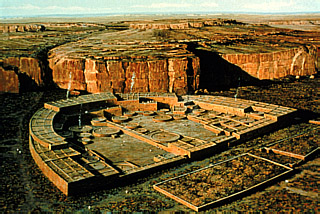
The central pueblo is called Pueblo Benito, from the air it is a neatly symmetrical D shaped village. This was the administrative, social and religious capital of their culture.
The unique feature of a pueblo is that the village is built almost as a single building, with hundreds of rooms which join on, either to the side or above and below, to each other. It is almost like life sized Lego, each room seems to be fixed to several others. At the centre of the Pueblo the building may be five stories high (at Benito anyway). As many as fifteen hundred people would live in a single Pueblo, perhaps each family had a room, though many rooms for other purposes than dwellings. Archeologists have found many other uses that the rooms were put to. Many of the rooms were for religious purposes, they are usually round and called Kivas. These rooms were either built round, or originally built square and had circular curtain walls added to them. The Chaco Pueblo builders had a similar level of masonry skill to builders of Europe, who were of the same era, between 900 and 1300 A.D. Their principle building system was the veneer wall, this being two thin layers of carefully placed stone, with the space in between being filled with rubble, just to give it bulk. exactly the same process was used in Europe to build castles and cathedrals. One major difference was that Puebloans did not seem to have discovered the concept of the arch. Although the rooms in a pueblo are usually quite small, with very few being more than 15 feet square, their Big Kivas are much bigger, being a circular room, dug into the ground, which was covered by a roof. Some of the kivas were 80ft across. The roofs were usually made from timber, held up by four pillars. Quite a clever construction. |
| Pueblo Benito as it looks now |
 |
| As it probably looked in 1200A.D. |
This was a very exciting day, which we enjoyed immensely.
Monday, April 13, 2015
Visiting Pueblo Villages
Salmon Ruins
Sunday was a quiet day for us, just a visit to Golden Corral for early tea.
Monday we drove the two miles to Salmon Pueblo. This was one of the satelite Pueblos to Chaco, built around the same time. It was interesting as it gave us some idea of what to expect at Chaco. It was very quiet and just about able to accomodate Sally and her electric chair. We spent an hour or two wandering around the ruins, working out the difference between Tower Kivas, Big Kivas and other Kivas (they are all circular constructions in stone used in worship by the Puebloans). Now we are ready for the Big One - Chaco!
Sunday, April 12, 2015
Pow Wow Weekend
Find our more about our Pow Wows using the tab to our Pow Wow Page
We have found out that the Pow Wow is to take place in part of the McGhee Fairground, in the indoor horse arena. A sand covered arena with seating round the outside. The doors open at 3.00 p.m. and the price for over 60's is - nothing! We arrived not knowing what to expect, just as well as we did not understand a thing! However after two days we had gained some understanding of what was happening, so will relate it with hindsight rather than actual experience. This is my own definitive description, so don't hold me to account for mistakes.The programme of events has three elements: Gourd Dance, Grand Entry and Competition. The cycle of elements is gone through on Friday night and repeated in sessions on Saturday afternoon and again on Saturday night, each cycle becomes more important and exciting. Each element is carried out with the precision of an Asian Wedding, you know the order it will happen in, you just don't know when it's going to happen.
I started to write a description of the Pow Wow, but it has gotten slightly out of hand, so I have published it as a separate page, rather than bore every who reads this.
Needless to say we really enjoyed our weekend being involved with Native Americans. Some of the highlights were as usual about meeting people. We sat in a different areas for each session and very quickly people around us got to talk with us. During the event I had noticed that the volunteers had very nice Tee-shirts and mentioned to one man, who was beautifully attired in his regalia that I would have liked to have purchased a Tee-shirt. He said "Wait here!" He wandered off to the main stage and spoke earnestly to the officials. Then he came back and asked us for our details. About an hour later the M.C. welcomed us as visitors from "Yorkshyre, England", I had to go up on the stage, we got a big round of applause and they presented me with two Tee shirts. We were deeply touched. Again we were touched when about 3 minutes later a man came up to us and presented us with a small decorative War Bonnett, saying that he wanted one of his pieces to be taken back to England. At one time we were talking to about half a dozen people, inspecting their costumes and talking about the dances. The man who had talked to the M.C. was not only a dancer, but also one of the judges (all the competitions needed judges) and it was great to just talk with him.
We had a wander round the vendor stalls and eventually bought a small, but very pretty, print. we had looked at buying a Navajo Rug, which had been made from scratch, spun, dyed and woven, by one of the vendors grandmother, but just as we were looking at them a woman came up and bought both of the rugs that were for sale! There were no other rugs for sale anywhere at the Pow Wow! we were disappointed, as all these vendors were genuine, selling indian goods to other indians.
I was also forced to buy a Navajo Fry Bread following a conversation with the two ladies who were outside the arena making and frying them. They only charged $2, usually at rodeos and festivals they are $5.
Because we were over 60 we did not have to pay to get in, so at one of the giveaways I went down on to the dance circle and put a contribution onto the blanket for the host Drum Crews, so at least I joined in a little bit.
The people we met there really made us feel a part of the Pow Wow, we most enjoyed watching the Grand Entry, which was very spectacular. We also enjoyed starting to understand some of the more subtle meaning behind things like the Gourd Dance, the place of Veterans and the importance of rank and age in their culture.
It was interesting just watching the dancers getting dressed, as the costumes are quite complex. Little things. We watched one lady (Tina) overcome the problem of sitting down with her Jingle costume, she wore shorts under her dress and just pulled it up round her waist to sit down. One lad, Ty, had an amazing blue and orange suit, with neck feathers and bustle. In the middle of the bustle he had a little badge with a Nike Swoosh embroidered on to it. I complemented him on his dress and asked for a photo. I mentioned the Nike Swoosh, to which he seemed very pleased. I then wondered if perhaps it was a Navajo symbol that had been stolen by Nike, so I looked that up and found it was designed by a woman in 1971 in Portland, Or, home of Nike. She was paid $35 for the work! Later she was given nike shares, which were then worth $150, but today are worth $680,000 - she still has them.
We saw one bustle which had the complete head and neck of an eagle in its centre. Though bustles are very important on their dress, I have no idea why they use them.
Overall it was a very pleasant experience. The only drawback was that because it was indoors our pictures are pretty rubbish, but they are a record. I am sure we will get to another one which is outdoors.
Thursday, April 9, 2015
Oh Wow It's a Pow wow
Find our more about our Pow Wows using the tab to our Pow Wow Page,
We left El Morro NM to drive North, hoping to reach Farmington, though it would be a longish drive for us. Our first stop was in Gallup, where we crossed Route 66 again. We were forced to stop for a coffee/tea at a small bakery called Glenns. I was forced to eat a huge apple fritter, fortunately Sally helped me out.Driving on North we passed Ship Rock (the rock) and stopped in Ship Rock (the town) for our packed lunch, arriving in Farmington in reasonably good time and feeling fit enough to drive out to get a steak at the Texas Roadhouse up the road.
Farmington in New Mexico is right in the middle of Indian Country, although not on a reservation. We have come back to here (our last visit in April 2011 coincided with the Royal Wedding- William and Kate) to attend our first Pow Wow. It is being held indoors, in a large arena at the fairground. We of course have no idea what to expect!! The trailer is installed in the fairground, we are on one of 500 odd hookup sites, yes, we are the only trailer on the entire fairground. We have taken a nice spot down by the San Juan River, the same one that passes through Bluff and Gooseneck State Park.
There is plenty of information about Pow Wows on the internet, but we feel we know nothing about the impending celebrations.
Wednesday, April 8, 2015
Atsinna, El Morro and Inscription Rock National Monument
Wednesday
Atsinna, El Morro and Inscription Rock, all three of these places are the same geographical location, but separated in time and culture. Atsinna is the Zuni Puebloan name for the village built on the top of the mesa, El Morro is its Spanish name and means The Headland and Inscription Rock is the name given to it by American travelers after they saw the many carvings that cover the headland walls (and added their own). El Morro is a sandstone mesa, which means it is a hill/mountain with very steep sides and a flat top. The top is longer than the sides are high, so it is a mesa. The other way round is a butte (my definition). They are often inaccessible, frequently described as an 'Island In The Sky'
Situated out in the desert, away from any river, El Morro's importance lies in a small pool at the base of The Headland which collects run off rainwater from El Morro, protected from evaporation by the surrounding rocks the pool is about swimming pool size, holding some 200,000 gallons of water and has water all year round.
The presence of water in the desert meant that it was significant to all who passed that way and so is a reflection of the history of this area.
There are three main groups of people who used this pool. The Zuni Puebloans (1200 - 1350), The Spanish explorers and settlers (1540 - 1780) and the American Immigrants (1846-1881) travelling to California.
I took off early this morning to walk the trail up onto the El Morro mesa, to see the Pueblo village (Atsinna) up on the top. built around 1275.A.D.(?) it is a building with 395 rooms, though very few of them remain, still it was a pleasant walk, including the somewhat narrow and precipitous path onto The Headland, in an increasing wind. Some lovely views of the surrounding area, which is very dry, with many Junipers Also saw an American Kestrel, which was very nice.
In the afternoon Sally and I took the short trail which takes you to the other main features of El Morro, the graffiti!
People would arrive at the pool and maybe stay a few days and the soft sandstone made the rocks round the pool ideal for carving names. So there are many names carved in the rocks. The modern name for El Morro is Inscription Rock. At various locations and even on top of each other there are pueblan petroglyphs (pictures), Spanish names and writings (even poetry), often in a neat cursive script and modern grave stone style carvings produced by the more modern Americans passing this way. The information booklet supplied showed us where many interesting carvings were. The first Spanish leader carving of his name 'Onates' in 1605 - 15 years before the Pilgrim Fathers landed at Plymouth Rock.
Some inscriptions of women and girls (Sarah Fox - aged 12 in 1858) were amongst over 2000 carvings which make this place so interesting and important.
Over 700 years of History are marked (literally) at this small oasis in the desert. A quite remarkable place to visit.
Tuesday, April 7, 2015
Lake Lyman to Zuni
At this point I was concerned that in crossing from Arizona to New Mexico we may, or may not be crossing a time zone. Since it would be losing an hour we played safe and put our clocks forward. As it happens Arizona and New Mexico are both on Mountain time, but Arizona does not using daylight saving time, so we left Arizona at 10.00 and arrived in New Mexico at 11.00. The drive again covered some very interesting desert country (no that is not a contradiction in terms, as most desert is interesting. Although “I-Spy something beginning with ‘T’” (trees) in the forest area gave way to “I-Spy something beginning with R’” (rocks) in the desert regions
First stop in NM is Zuni, the ancestral home of the Zuni Pueblo People. We stopped in the town and had an interesting time of learning at the visitor centre, as well as learning about the people we found out where we could get a cup of coffee/tea and also that the pueblo village was closed for private ceremonies, so we couldn’t see much here. Anyway we had a cup of coffee/tea and continued East to El Morro National Monument. Doesn’t look much on the map, but it is an amazing place. First of all the campground is free, we managed to get the last site that was big enough for our rig, so it was a good job we had set out early (compensating for the time loss across time zones).
Monday, April 6, 2015
To Springerville and Lake Lyman
Monday morning we were up early and drove on another 100 miles to Lake Lyman, right on the Easter border of Arizona. This reservoir is right in the middle of desert, so looks pretty bleak, so another quiet night. On our way we took in the town of Springerville, where we sought out the ‘Madonna of the Trails’, One of twelve statues that can be found on the National Old Trails Road, which is one of the pioneer trails of the 1850’s. The Statues were commissioned by the National Society Daughters of the American Revolution and place in 1928 and placed in locations from Pennsylvania to California. The statues tried to show the characteristics of the pioneer woman, with cradling a baby, pushing a child and carrying a gun. Originally the statues showed the woman looking West, but it seems that the statue in Springerville has been moved and the woman now resolutely faces North! Still it was very interesting.
Saturday, April 4, 2015
East into Empty Spaces on the Map
Sunday
Sunday
Hitched up the wagon and moved East. The problem with traveling, and I still haven’t learned the lesson, is that on the map, what looks like an empty space put there to separate two interesting places, which you just have to drive through, is in fact full of interest and beauty. As you drive through these empty spaces it has the rather depressing effect of making you realise that rather than passing through one should be spending time exploring and enjoying the views, history and culture of the area. However one then has to temper that with the knowledge that Arizona is 400 miles North to South and 300 miles from East to West and we have spent a maximum of 2 months in the State on four of our trips. Imagine trying to explore somewhere three times the size of England without leaving bits out, can’t be done.
One such area is the Mogollon Rim. It is actually the South West edge of the Colorado Plateau, which stretches from Kingman on the West border with California to the Eastern border with New Mexico. The countryside to the East of I17 and to the North of Phoenix is the part we are travelling through. It is best known to the citizens of Phoenix, who use it as an escape from the summer heat, as it is 6-7000ft up and about 20°f/10°C cooler. Expecting to drive right through we found that it was a very pretty landscape full of interest. It also passes through several National Forest areas, Tonto and Sitgreave being two. We had planned to stay in one of the Forest Service Campgrounds, only to find that they are still closed for the winter. Oops!, so we found a quiet forest track and puled up into the forest to spend the night. It was very quiet and free.
Day Trip To Jerome
We had a very pleasant day out, going up country, past Cottonwood, to Jerome. Jerome was a big mining town from 1870 onwards. It reminded us very much of a small version of Bizbee, in Southern Arizona, which we visited in 2013. Arizona has lots of copper, copper is not conducive to small mining operations as the copper is usually extracted from a variety of ores, so usually the copper mines are run by large companies, which was the case in Jerome, partly open caste and partly underground the town was split between two large mining operations, Little Betsie and the Verde Mine. By the time they were worked out the shafts went down more than 4,500ft below ground, almost down to sea level. The town hangs on the mountainside, with steep roads winding back and forth across the mountain and houses and shops being built onto any flat space available. At it’s height 15000 people lived and worked here. By the turn of the century there was lots of money, so the town had many sophisticated services, such as movie theaters, train service, buses, automobiles and of course lots of saloons and bordellos.
Later, with lack of space, miners moved to Cottonwood, where there was more room. However when the mines gave out Jerome emptied, almost overnight, leaving a ghost town of perhaps 50 people. Just like Bizbee, it stayed that way until the late 1960’s, when Hippies, moving out of California, moved in and squatted. This has produced a town which is a strange combination of mining and art, quite interesting to walk around.
While we were there we bought coffee/tea in the Mile High Grill and bought a couple of very nice looking mugs. We were also pressed to try the Cream Filled Cinnamon Coated Curros (pro. Churros), which were very passé, about 6 inches long, a thick pancake mix which has been extruded from a star shaped nozzle, filled with cream and deep fried, sort of a cross between a pancake, a donut and a stick. Interesting to look at, but not brilliant to eat, a waste of my precious calories, still you have to try these things.
After wandering round the town we moved on to the Douglas Mansion, sounds grand, but it was not very, however it was just by the Little Betsie Mine and belonged to the mine owner. Here we were able to get at good understanding of the story of the town. There was also a great model showing the extent of the underground workings, where the copper was found, how the two mines related to each other and also the fault line which exposed the copper ore in the first place. Outside we also saw the little ore cars which looked like they were straight out of Indiana Jones and The Temple of Doom.
Overall we had a very enjoyable day.
Tomorrow we move on.
Friday, April 3, 2015
Only In America
Friday - Good Friday at that
Today was to be a rest day. We rose late and caught up on the laundry. Here we made new friends who introduced us to the delights of dominoes, like American Bingo, qute different to the English counterpart. No dots! numbers on the doms and some strange rules, but great fun with a group of old timers and the owners of the RV park.
One dear lady, called Joy, I had already met in the park, while she was walking her dog, Napoleon, just for the exercise, complete with her oxygen bottle. When I say she was walking her dog, I of course mean that the dog was walking, she was riding a golf cart, but napoleon was walking on a leash. So there was a gfreat picture of Joy on the golf cart with old Napoleon walking alongside.
I could not resist stopping and talking with her, whereupon she introduced me to Napoleon. I suggested that this was extremely good exercise! For Napoleon anyway. Not so much cardiovascular exercise as Cartiovascular exercise, Golf cartio exercise! Only in America.
Thursday, April 2, 2015
Out and About in Cottonwood
Thursday
We thought a short excursion today would be a good plan, so we pakced a picnic and set off 15 miles up the road to Cottonwood, a dormitory town from the last century, where 15,000 miners lived. They worked at ta number of silver and copper mines around the place, but lived in Cottonwood.
In reality the Old Town turned out to be just a main street of art, trinket and antique shops, interspersed with cafes and bars.
However we had a very pleasant cuppa, a nice stroll and a picnic on a local trail to the riverside.
On returning we stopped off at Walmart to return a Bissell vacuum, that did not have a crevice tool!
Wednesday, April 1, 2015
The Last Saguero
Wednesday
 |
| The Last Seguero |
On reaching the outskirts of Phoenix we stopped at Desert Donuts. We had stopped here on the way South and really enjoyed the place, we were not disappointed this time either. I forced myself to eat a caramel chocolate donut with my coffee. Sally helped my conscience by having a big bite, so we left quite happy really.
Driving North I felt quite heavy hearted as the realization hit that we were unlikely to visit Pheonix again. This was highlighted as we watched that symbol of the SouthWest, the Saguero Cactus, passing by on the roadside. They have a very specific habitat and as we moved North they began to thin out and the concept of 'The Last Saguero' was ever-present. So Sally started to take pics of these amazing plants, even though we have quite a few already. As we moved North and higher they thinned out and we felt the end was near.
Finally we pulled uphill from Black Canyon and there on the skyline stood a single Saguerro, standing on the borders of its domain, waving farewell to us as we climbed out of the desert region, which they cannot leave. We passed this lonely cactus, turned a bend and reached the top of the climb. We were now on the plateau and grassland, prickly pear, mesquite and creasote bushes took over, but alas no Seguero.
Unfortunately Sally did not get a pic of it, however, on looking on Street View I found a picture of it.
Unfortunately Sally did not get a pic of it, however, on looking on Street View I found a picture of it.
It was for us, indeed, the last Saguerro.
Subscribe to:
Posts (Atom)